Cartography
Welcome to the Map Library of the Cocos Island Geoportal. Here you will find an extensive collection of thematic maps in PNG format, organized into three main categories: Protected Wild Areas of the Cocos Marine Conservation Area, Cocos Island maps and regional maps of the Eastern Tropical Pacific Ocean. Each map includes a description and citation guide, facilitating their use in research, education and environmental management projects.
PROTECTED WILD AREAS OF COCOS MARINE CONSERVATION AREA
.webp)
Cocos Island National Park and Bicentennial Management Marine Area (2021)
Updated map of the Protected Wild Areas of the Cocos Marine Conservation Area (ACMC), with delimitations in force from 2021
.webp)
Cocos Island National Park and Bicentennial Management Marine Area (2011-2021)
This map compares the boundaries of Cocos Island National Park and the Bicentennial Management Marine Area in 2011 and 2021, highlighting changes made in 2021
.webp)
Cocos Island National Park and Bicentennial Management Marine Area (1978-2021)
Poster showing the expansions of Cocos Island National Park and the creation and expansion of the Bicentennial Management Marine Area between 1978 and 2021
.webp)
Coordinates of Protected Wild Areas of Cocos Marine Conservation Area (2021)
Map showing the geographic coordinates in latitude and longitude of the vertices of the Protected Wild Areas of ACMC, including Cocos Island National Park (PNIC) and the Bicentennial Management Marine Area (AMMB)
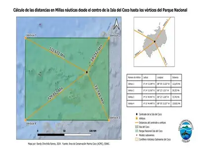
Distance in nautical miles between Cocos Island and the vertices of Cocos Island National Park
Map illustrating the distance in nautical miles from the center of Cocos Island to the vertices of the National Park
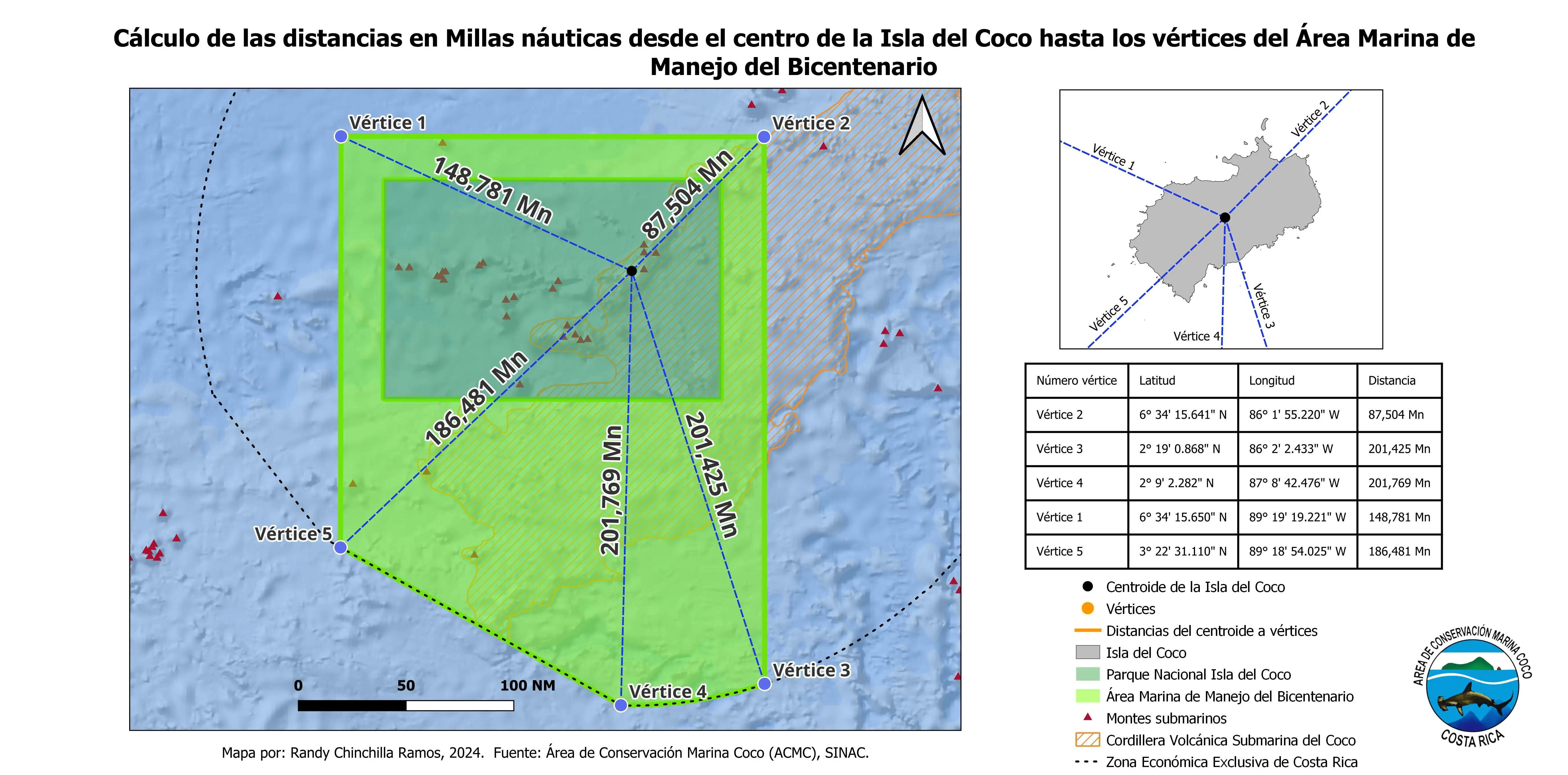
Distance in nautical miles between Cocos Island and the vertices of the Bicentennial Management Marine Area
Map showing the distance in nautical miles from the center of Cocos Island to the vertices of the AMMB
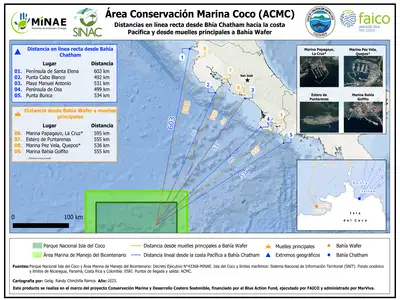
Distance in nautical miles between Cocos Island and Costa Rica
Map presenting distances in kilometers from Wafer Bay and Chatham Bay to ports and key points in Costa Rica
COCOS ISLAND MAPS
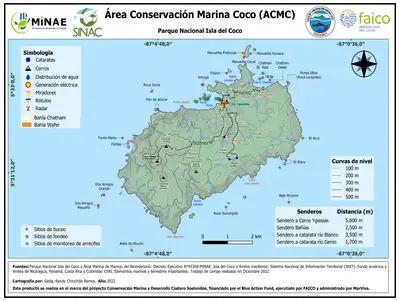
Geography of Cocos Island
Map detailing the physical geography of Cocos Island, including mountains, valleys, rivers and coasts, providing a clear view of relief and key natural features
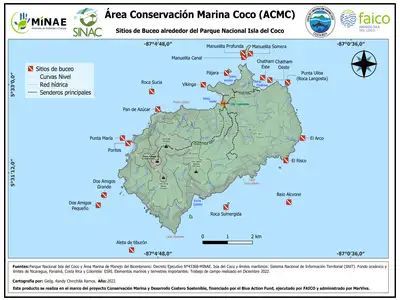
Diving Sites of Cocos Island
Map showing the location of the 19 diving sites authorized by ACMC, managed according to their carrying capacity to preserve the natural environment
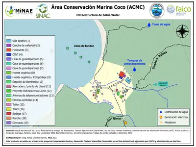
Wafer Base Infrastructure
Detailed map of the facilities at Wafer Base, including administrative areas, workshops, warehouses, recreational areas and beach access

Geomorphology of Cocos Island
This map highlights the geological and geomorphological formations of the island, including cliffs and geological faults
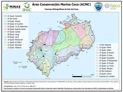
Hydrographic Basins of Cocos Island
Map of the main hydrographic basins of the island, showing rivers and streams
REGIONAL MAPS
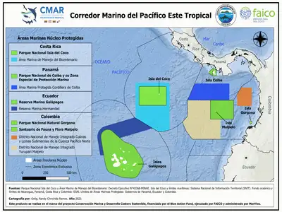
Eastern Tropical Pacific Marine Corridor 2024
This map illustrates the Eastern Tropical Pacific Marine Corridor (CMAR), highlighting protected areas and key marine conservation zones throughout this oceanic region. The CMAR encompasses marine spaces of Costa Rica, Panama, Colombia and Ecuador, connecting sites of great biodiversity such as Cocos Island, the Galapagos Islands, Coiba National Park and the Malpelo Marine Reserve.
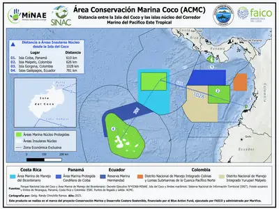
Distances between Cocos Island and CMAR
Map showing distances in nautical miles between Cocos Island and key points within CMAR, such as the Galapagos Islands, Malpelo and Coiba
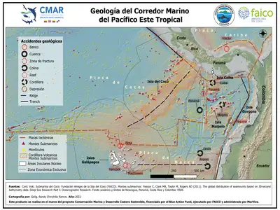
Geological Framework of the Eastern Tropical Pacific
Map illustrating the geological characteristics of the Eastern Tropical Pacific, highlighting faults, ocean ridges and underwater volcanoes